
Geary County
County Seat: Junction City
County Size: 385 square miles
County
Checklist: 326 species
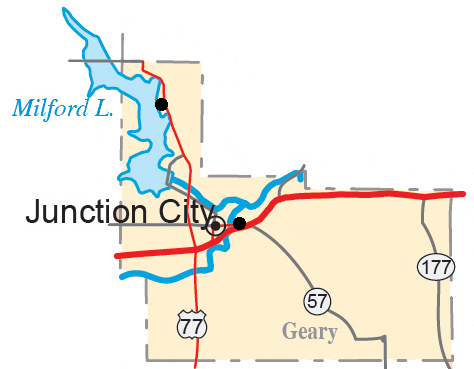
DeLorme pages 36 & 37
Best Birds: Brandt (1994), Pacific Loon (in breeding plumage, late June 1998), Gray Hawk (1990), Black-legged Kittiwake (2008), Pomarine Jaeger (1991), White-throated Swift (1990), Lewis’s Woodpecker (2001), Pygmy Nuthatch (1985), Virginia’s Warbler (1999)
Geary County is the second smallest county in land area in the state. But due to its intriguing mix of ecosystems and habitats it has an impressive bird list of 323 species. The Smoky Hill River and Republican River join in Geary County to form the Kansas River. The Kansas River serves as a riparian corridor allowing birds of the eastern deciduous forests to travel deep into the Flint Hills tall grass prairie. Ft. Riley spans both Geary and Riley counties and provides some very good dense riparian “old growth” forests. Upstream from Junction City the Republican River is dammed to create Milford Lake, a Corp of Engineers flood control project. At conservation pool, Milford Lake is the largest reservoir in Kansas, technically in three counties, Geary, Clay and Dickinson. Milford Lake and Ft. Riley create the uncommon Kansas situation of having a great deal of public land accessible for birding. All of these features lie in the north end of the county. As you move south through the county you traverse several creek valleys that are farmed while the ridges in between are still in their native tall grass prairie condition. This wonderful mix provides birders the opportunity to see forest specialists and grassland specialists just a few miles and a few minutes apart.
Birding Locations:
1. Milford Lake – Located just northwest of Junction City, Milford Lake is a US Army Corps of Engineers flood control project built in the 1960s on the Republican River. At conservation pool the lake covers a little over 15,700 surface acres in Geary, Clay and Dickinson counties. This area is surrounded by over 23,000 land acres of publicly accessible area including wetlands, grasslands and timber. To reach Milford Lake; from the intersection of K57 and US77 highways, proceed west on K-57 about 2.4 miles. This will take you to the south end of the dam and the Corps of Engineers Office where maps and brochures of the area can be found. The large expanse of water is very attractive to waterfowl and water birds of all kinds including loons, grebes, herons/egrets, geese, ducks and gulls. Because of the size of the lake, watching waterbirds and waterfowl on the main body of the lake often requires a spotting scope and even then identification can be difficult due to wind, wave action and heat distortion coming off the water. Water levels can fluctuate up and down due to high rain event inflows, or releases for downstream water quality/quantity. When there are drawdowns, extensive mudflats develop that are attractive to shorebirds in migration. High water events can prevent challenges for access, but as the water starts to recede the recently flooded areas can also provide great habitat for shorebirds and larger wading birds. There are many accessible areas around the lake. Numerous campgrounds around the lake are busy in the spring, summer and early fall. In late fall and winter these areas are closed, but they can still be accessed by walking and can provide great birding opportunities. Some of these areas also have large stands of pine trees (pines are not native to Kansas). In recent years drought and disease have started killing these trees but large areas of pines do still exist around the lake in areas and often hold specialty species like Red and White-winged Crossbills, Evening Grosbeaks, Red-breasted Nuthatches and Long-eared Owls.
Following are some of the preferred birding areas in the Geary County portion of Milford Lake. Refer to Clay and Dickinson County for birding areas around Milford Lake in those counties. The outlet area downstream (to the east) of the dam can provide excellent birding. Fall, winter and spring, the Republican River immediately downstream from the outlet tube can contain good numbers of gulls and waterfowl. In the coldest weather this may be the only area of open water and will concentrate birds accordingly. The trees along the south side of the Republican River can hold good numbers of Bald Eagles from November through March. The two ponds in the outlet area can also hold good numbers of gulls and waterbirds throughout the year. There are walking and biking trails around these ponds, and along the river, to provide good birder access. In recent years Pileated Woodpeckers have moved into the outlet ponds area and can occasionally be seen throughout the year. In 2012 Bald Eagles nested along the old Republican River channel to the north of the Gathering Pond (the easterly pond of the two). The Milford Nature Center is also in this area and is a wonderful place to learn more about the wildlife in the Milford Lake area. The Milford Nature Center holds an annual Eagle Days every January, the weekend immediately before Martin Luther King Day.
Other areas that should be considered for birding on the east side of the lake include the north overlook area, just north of the dam. This location provides a good vantage point to scope the lake. The Milford State Park area requires a permit (annual or day use) but provides good timber areas and additional vantage points to view the body of the lake. Further north on US77 is the Farnum Creek campground area with large stands of pines that should be investigated when the campground is closed for the winter. Where US77 crosses the Farnum Creek arm of the lake the road is wide enough to allow parking and viewing of the lake. Northeast of the bridge about 0.5 mile has been a Bald Eagle nest for several years. It can be easily seen in the early part of the season but then becomes obscured as the trees leaf out. Just north of this bridge, on the east side of the road, there is a turnout where you can park and then walk back along the short bridge and causeway area to glass the water and surrounding trees. From this parking area you can also venture down a short unimproved trail to an old bridge where you can get a closer view of some of the areas. Continuing north on US77 you start to encounter the Ft. Riley Military Reservation on one or both sides of the road. Observe warning signs before entering any Ft. Riley area. Please view the special section on Ft. Riley for more information on accessing birding areas there. An arm of Milford Lake extends into the Madison Creek area that is crossed by US77. The area on the north side of the highway is sheltered from strong south winds and can hold many birds in windy weather. It is also fairly shallow so when water levels drop the mud flats can be attractive to shorebirds. Areas further upstream on the lake are in Clay County. Refer to the Clay County account for those areas.
On the south side of Milford Lake, the southernmost portion of the lake comes up to K244 highway. Park on the shoulder and scope this cove. Waterfowl, gulls and shorebirds can all make use of this area. Just east of this area, Gfeller Road goes south. Pull off at this intersection. Painted Buntings nest in this area and can often be seen and heard singing from the cedars across the road to the north or from the utility lines overhead. The pasture on the southwest corner of this intersection is public access land and Henslow’s Sparrows have been known to nest here. All through this area listen for Bell’s Vireos. They are a common nesting species in the shrub thickets here. A little further west, on K244, is the entrance to the West Rolling Hills area. This area holds extensive stands of evergreens. At times these have held roosts of Long-eared Owls as well as feeding sites for Red and White-winged Crossbills. Just north of the West Rolling Hills boat launch is a point that allows good access year round to scope the lake. West Rolling Hills also holds a large campground. Once this campground shuts down for winter it can provide excellent birding. Park at the locked gate and feel free to walk in. One the west side of the lake is the Curtis Creek campgrounds which are also a good place to bird when closed for the winter. The Curtis Creek boat launch is in an area of fairly shallow water so low water events can provide extensive mud flats that are worth investigating. Further north, in the very northwest corner of Geary County, is the School Creek campgrounds and recreation areas. This location offers good views of the lake.
While campgrounds and Corp of Engineers park areas are no-hunting zones, birders need to be aware that areas outside this are public hunting and opening days of the various hunting seasons may not be the best time to be out birding.
DeLorme: 36, E5, F5, G5
2. Geary State Fishing Lake – Located in the southwest portion of Geary County is the Geary State Fishing Lake, managed by the Kansas Department of Wildlife, Parks and Tourism, a 450 acre mixed habitat area of public access. The southeast arm of the lake (nearest to US77) has a small wetland area and possible mudflats under low water conditions. The small creek that feeds into this arm is nicely forested and holds a reliable place to find American Woodcock displaying in March. Turn off US77 and take the left fork at the first place that the road divides. This leads into a primitive campground area and shortly after sunset in March you can find displaying woodcock in the north end of the campground. This forested area is also a good place to find warblers and vireos in migration. The upland areas with grass, forbs and shrubs can also be a very good place to find sparrows and on quiet summer evenings one can hear Common Poorwills calling from the grasslands.
DeLorme: 36, I5
3. Ft. Riley – Ft. Riley is a 101,000 acre active US Army Reservation in Geary and Riley counties. While much of the area (roughly 71,000 acres) is open to outdoor recreation much of the public access areas can be closed at different times for training maneuvers. Birders need to pay attention to check-in procedures and open areas. Stay updated on open areas as they change daily. Everyone entering Ft. Riley, unless they have a Department of Defense ID badge, must enter through the visitor center at Marshall Army Airfield, Exit 301 on I-70. Allow at least 30 minutes for the initial check-in process; longer at busy times. Additional important information about birding on Ft. Riley can be found here. While much of Ft. Riley is in Riley County there are a few areas on the south side of the reservation in Geary County that are of birder interest.
Moon Lake/Pet Cemetery Trail: Entering Ft. Riley at either the gate at the end of Grant Avenue or Washington Street you will see signs to Moon Lake. If you enter on the Grant Avenue gate and proceed straight ahead through the stop light (Hubner Road), go up the hill and around a curve and immediately look for a small road on your left (north). This is directly across the road from the west end of the Main Post Ft. Riley Cemetery. Drive a short distance on this road to a small parking area and you are at the south end of the Old Pet Cemetery. From this location a trail meanders through the “old growth” forest eventually ending at the corner of the playground equipment on the southeast corner of Moon Lake. This trail is approximately ¾ of a mile long and offers truly spectacular birding in spring migration and early summer. (Early on, the trail splits (from the south entrance) and a second trail takes off and goes up the hillside to the Outdoor Chapel area presenting an excellent view of the river valley and Junction City.) the main part of the trail to Moon Lake holds nesting species that one may not expect this far east in Kansas including Yellow-throated Vireo, Wood Thrush, Kentucky and Black-and-white Warblers, Louisiana Waterthrush, Northern Parula, as well as Summer and Scarlet Tanagers. In migration one can expect many more species of flycatchers, vireos, thrushes and warblers.
DeLorme: 37, G6
First Territorial Capitol: If one continues on Hubner Road, through the main post area and past the Ft. Riley Hospital you will find the First Territorial Capitol building of Kansas. Behind this building there is a stairway down into the flood plain riparian forest of the Kansas River. A trail traverses this area and can provide excellent birding with some of the same species as reported from the Pet Cemetery Trail area. Throughout both of these areas Chuck-will’s-widows call and nest and Eastern Whip-poor-wills can be heard in spring migration.
4. Highland Cemetery/Homer’s Pond – Within the city limits of Junction City are a couple of good birding locations. Highland Cemetery is in the south central part of Junction City. This century old cemetery has had some amazing bird records associated with it. It is located on Ash Street 1.3 miles east of US77. Ash Street is the first stoplight north of I70 on US77. Turn east on Ash Street, travel 1.3 miles and turn south into the cemetery which is open from dusk to dawn. While many of the old pine trees have died, there are still enough evergreens present to make this area attractive to many birds. In December 1985, 2 Pygmy Nuthatches were present for several weeks including for the Christmas Bird Count. Pine Siskins and Red Crossbills have both nested in the cemetery and this was likely the location of the first Mississippi Kite nest in Geary County. Red-breasted Nuthatches are common in irruption years and Pine Warblers frequent this area in migration.
Homer’s Pond is an old farm pond that is now well within the city limits and maintained as a nice undeveloped park area but with a good accessible concrete trail all around it. Starting at the US77 and Ash Street intersection, turn east on Ash Street but just go 0.8 miles to the stop sign and turn north on Eisenhower Drive. Travel roughly one half mile and you will see Homer’s Pond on the west side of the road. You can turn west on Spruce Street just as you get to the pond and also park along the street here. The best birding is in the heavily wooded area at the south end of the pond. Walking the sidewalk around this area can provide some excellent passerine birding in the spring.
DeLorme: 36, H5
5. Walla Walla Road – On the northwest edge of Junction City, is a short county road known as Walla Walla Road. Recent (2016) changes to US-77 have turned Walla Walla into a dead end road only accessible from the west. From Exit 295 of I-70, go north on US 77 4.5 miles to the intersection of US-77 and K-57 (There is a stop light at this intersection.) Turn west and stay in the left hand lane, bearing left and staying on K-244. About one mile from the split, turn left (south) on Munson Road. In about 600 feet Walla Walla Road is on your left. It is 1.7 miles long and is private property on both sides of the road its full length so restrict your birding to the road. . There are two unnamed creeks along here, nice old trees and a rock face to the south. Park anywhere along here and walk the road from one of the small bridges to the other. This area is usually good birding year round and almost anything can be expected. Many good warblers and vireos have been seen along here as well as flycatchers. In recent years Pileated Woodpeckers have been found along here and Red-shouldered Hawks have nested here. The eastern creek is very seasonal and is usually dry unless there has been wet weather recently. The western creek is spring fed and usually has water in it. Wood Ducks nest along this area as do Louisiana Waterthrush, Northern Parula and Summer Tanagers. Barred Owls nest along this area too. Painted Buntings still nest in the area of Walla Walla Road but the overgrown pastures seem to have reduced their numbers and moved them a bit. They are most regularly found at corner at the top of the hill where the road turns and heads south towards the dead end. Learn the calls, listen and be patient. The best time to find them is mid May through late June.
6. Greater Prairie-Chickens – Over 50% of Geary County is tall grass prairie. This area is south and east of Junction City. County roads through this area often follow the creeks or cross over the ridges. Driving through any of these areas will reveal many grassland nesting species in the spring and summer including Upland Sandpipers and Scissor-tailed Flycatchers. Driving these roads in late March and April, immediately following periods of controlled burns of the pastures, can also reveal flocks of American Golden-Plovers foraging on the freshly burned pastures. Perhaps one of the most sought after birds of the tall grass prairie is the Greater Prairie-Chicken. The best time to view these grouse is in the late winter and spring when they are on their breeding display grounds or leks. Virtually all of these are going to be on private property. During other times of the year, viewing prairie-chickens is likely going to be a hit or miss opportunity. Fall viewing can sometimes be done at sunup and sundown if you can find areas where flocks of prairie-chickens are flying from roosting areas into grain fields to feed. One fairly reliable lek in recent years is visible from a county road.
From the I70 and US77 intersection, drive south on US77 8.3 miles. K157 highway goes to the west (right), but you want to turn left (east) on Skiddy Road. Travel 1 mile east on Skiddy road and then turn south on Hard Rd (graveled). As you drive slowly south, the east side of the road will start as pasture and then becomes a crop field. The lek is on this crop field a few hundred yards east of the road. Birds are most commonly going to be present from before sunup to a few hours after sunup. Stay in your car and the birds should remain active on the lek. Under no circumstances should you cross the fence as this is private property and it will spook the birds off the lek. It isn’t uncommon for males to start showing up on the lek in January and be present until clear into June. The females are only going to be present in March and early April and that’s when the numbers will be at their peak. Depending on what the previous year’s crop was will greatly impact visibility. If wheat is planted or soybeans were planted the previous year, there will probably be excellent visibility. If the previous crop was grain sorghum or corn, the standing crop residue may impede your view. If there are no Prairie-Chickens here, continue south to Tri-County Rd (or Ave A if you use the Morris County naming system. This road is the county line - to the south is Morris County, Geary County on the north.) Turn east (left) on Tri-County Rd and drive 1.25 miles, stop and scan the horizon to the north. The field to the north goes up and right at the top is a fairly reliable lek. Remember that this is all private property - stay on the road.
DeLorme: 36, I5
7. Accessible Sewage Lagoons – The small towns of Milford and Grandview Plaza have sewage ponds that are fairly accessible and can provide some interesting waterfowl in spring and fall.
Grandview Plaza is immediately east of Junction City and right off I70 at Exit 299. The main street north into Grandview Plaza is State Avenue. Take this all the way north through town. As you go past the last houses the road will start to drop down into the Smoky Hill River flood plain. The sewage lagoons are on the right (east) side of the road. Pull into the driveway and you can glass the water for waterfowl. Tundra and Trumpeter Swans as well as many different species of ducks and geese have been viewed on these lagoons.
DeLorme: 37, G6
The small community of Milford lies on the shores of Milford Lake, right off US77 towards the north end of the county. The sewage lagoons lie on the southeast side of town. As you approach the town of Milford from the south on US77 you will cross the bridge over the Farnum Creek arm of the Lake. Just north of this bridge is the Houston Road intersection. Turn left (west) and follow this road into the southeast corner of the town of Milford. In about 1 mile you will find an un-named road that takes off to the right. Follow this drive to a small parking area at the fence of the lagoons. Even though these sewage lagoons are very close to Milford Lake, they often still have open water when the lake is frozen. They can hold many waterfowl and gulls and are worth a quick check.
DeLorme: 36, E5
Updated April 2016 - CEO